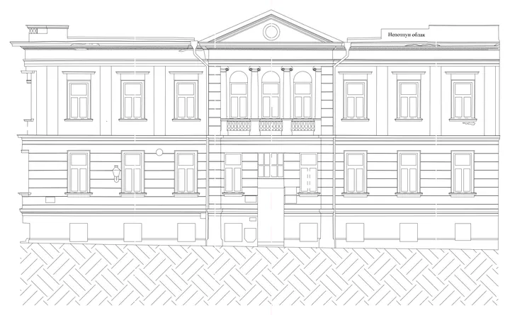
Facade of two old buildings, shown from a point cloud CAD drawing of the same facade, made from the point cloud CAD drawing Point cloud

3D laser scanning and CAD drawings

Laser scanning

The as-is state of a building, measurable from your office

Terrestrial laser scanning records the as-is state of a building or terrain as a three-dimensional cloud of hundreds of millions of points. With the Leica RTC360 scanner, which measures up to 2 million points per second, we capture a complete, measurable digital record of facades, interiors, industrial plants, bridges or installations in just a few hours.

Instead of going back to the site, your team takes every measurement directly from the model. From the same point cloud we produce plans, facades and sections, 3D models and BIM data.

Request a quote
  • 2 millionpoints per second measured by the Leica RTC360
  • A few hoursinstead of days of conventional measuring
  • Millimetre accuracya measurable digital record of the whole building
What we deliver

From point cloud to finished drawing

  • Point cloud

    Registered and georeferenced, in E57, RCP/RCS and LAS formats.

  • 2D drawings

    Plans, sections and facade elevations in DWG and DXF.

  • 3D and BIM models

    Scan to BIM in Revit and IFC formats.

  • Virtual tour

    360° panoramas, in TruView or on the web.

  • Deviation analysis

    Floor flatness, wall and column verticality, as-built compared with the design.

  • Calculations

    Areas and volumes taken directly from the captured data.

Projects

What a point cloud can do

Scanning and engineering surveying

Multi-storey building under construction, Belgrade

We scanned the building and used the point cloud to produce elevations of every side and 24 horizontal sections through its height. The footprint at each section is shown together with the site axes, and we calculated areas from the same data.

This is where laser scanning meets engineering surveying: the as-built state is checked across the whole building, not at a few points.

Elevation of a building under construction from a point cloud, with the outline drawn on it
Elevation from the point cloud
Horizontal section of the building with its outline and the site axes
Horizontal section with site axes
Facade drawings

Facades of old buildings

On buildings with rich facade decoration, every detail matters: cornices, railings, windows and ornaments. We scanned the facades and drew them in lines from the point cloud, to scale and with height dimensions, as a basis for conservation and renovation. You can compare one example in the image at the top of this page.

CAD drawing of an old building facade with rich decoration
CAD drawing of the long facade of a multi-storey building
Process

How we work together

  1. Agreement

    We discuss your needs, level of detail (LOD) and formats.

  2. Scanning

    We work on site without disrupting the building.

  3. Processing

    We register the scans and process them into one point cloud.

  4. Delivery

    We produce the drawings or models and deliver them in the agreed format.

  5. Ongoing cooperation

    When needed, we produce new drawings and sections from the same point cloud, without another site visit.

FAQ

Questions about laser scanning

01How accurate is the scanning?

Scanning accuracy is at millimetre level.

02What format will I get the results in?

We adapt to your software: AutoCAD, Revit, ArchiCAD, ReCap and others. We deliver point clouds in E57, RCP/RCS or LAS formats and drawings in DWG and DXF.

03Does scanning disrupt the building?

No. Scanning is done without disrupting the building, and nobody has to climb to hard-to-reach spots.

04What is a point cloud?

A set of millions of measured points that together show a building accurately in 3D. Measurements, drawings and models are taken from it without another site visit.